Singapore Expansion:
How Dredging Transformed an Island Nation Into an Industrial Capital
Brantz von Mayer and The Writers for Hire
Overview
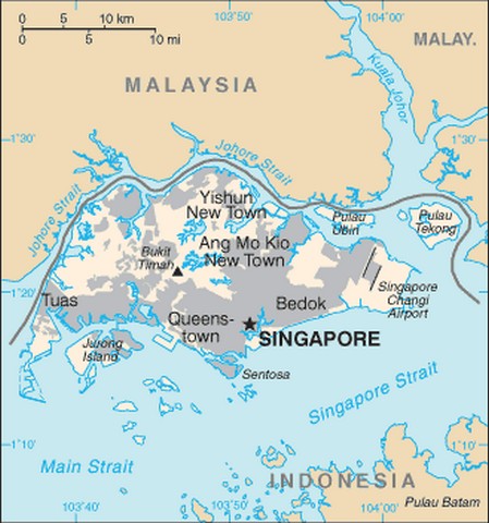
A scant five decades ago, with a GDP of less than $320 per capita, no real industrial infrastructure, and only meager land resources, the city-state of Singapore was hardly a player on the world economic stage. However, what the tiny country did have was a longstanding entrepôt tradition on which to expand , as well as a prime trade-route location that offered an almost unparalleled potential for shipping on a grand scale. (1) (2)
Today, Singapore has surpassed Hong Kong and Rotterdam, and is second only to Shanghai as the world's busiest transshipment port. With a current annual per capita GDP of $60,000 (a staggering $3 billion total), the once insignificant country has become the 15th largest trading partner outside of the U.S. In addition to boasting more than 3,000 multinational firms in banking, manufacturing, biotechnology, and oil refineries, a burgeoning state-of-the-art medical tourism trade, a thriving culinary scene, exclusive casino resorts, and natural attractions including a zoo, night safaris and a nature preserve, the country is also enjoying success as a travel destination that pulls in more than 10,000 visitors annually.
None of this would have been possible without dredging.
The Petrochemical Connection
How does a tiny country with no oil reserves of its own become home to over 100 global petroleum and petrochemical companies? In Singapore's case, the answer was to make these companies a home.
Despite a diminutive geographic footprint and limited national resources, Singapore was determined to make its mark in the world. Realizing the key to economic development was industrialization through globalization, Singapore's leaders began to throw their nets outward. They hoped that by establishing a business-friendly environment that featured low taxes; a stable, law-abiding society; and a willing workforce, they would attract international investors. Their gambit paid off royally.
During the mid-1900s, the government touted itself as the ideal locale for heavy industry _ and several major international companies (including Esso, Mobil, BP, Shell, and Phillips Petroleum, and Sumitomo Chemical) jumped at the invitation.
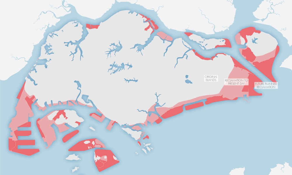
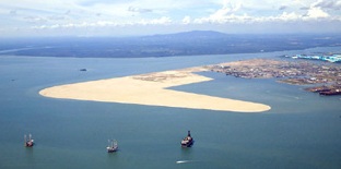
Singapore Expansion
Pink areas illustrate the land created circa 2013
Red areas illlustrate planned future expansion
Photo Source
But by the 1980s, it was clear that Singapore had gotten a little ahead of itself. Although it was a good problem to have _ too many interested parties _ the country was running out of land. For the desired rapid growth and industrialization to continue, some strategic planning was in store.
Toward this goal, Singapore has invested well over $10 billion in two major land reclamation projects in its southwest corner, Jurong Island [internal link to section in this article] and the Tuas Peninsula [internal link to section in this article]. Together, these projects have formed a massive industrial area that helped the country position itself as the international hub of the petrochemicals industry. Since the Jurong and Tuas reclamation efforts began, this petrochemical cluster has attracted more than $42 billion in investments. And the presence of so many international companies in one place has become self-reinforcing: This critical mass fosters economies of scale that continue to lure additional industry giants. Now, thanks in great part to capital dredging, the region is the third-largest oil refining and petrochemical hub in the world.
Ongoing reclamation has increased Singapore's land area almost 20% – from 224 square miles (580 square km) since independence in 1965 to 272 square miles (704 square km) today. Future capital dredging could expand the total inhabitable topography by another 40 square miles (100 square km) by 2030 in order to accommodate both industry and a projected population of 6.9 million. (3)
Jurong Island: Seven Become One
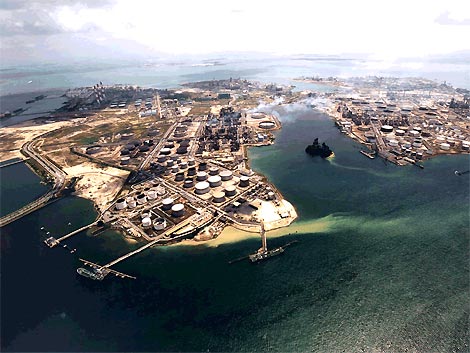
Jurong Island – the first of these two massive land reclamation projects – is the result of creative engineering. Seven existing islands (Pulau Merlimau, Pulau Ayer Chawan, Pulau Ayer Merbau, Pulau Seraya, Pulau Sakra, Pulau Pesek, and Pulau Pesek Kecil) off the southwestern corner of Singapore's main island were merged into one. The result: Jurong Island is now the country's largest outlying island. Through massive capital dredging, this 12 square-mile (32-square-km) area of usable land grew from an initial area of less than 4 square miles (10 square km).
Jurong Dredging and Reclamation
The official discussion regarding the merits of joining the islands to create a complete industrial hub began in 1984. In 1991, the government approved plans to unite this group of separate islands for a $5.6 billion price tag. Jurong Town Corporation (JTC) was charged with planning and coordinating the infrastructure of the new colossal island, with the Japanese construction outfit PentaOcean handling the bulk of land reclamation.
Although the dredging process itself was certainly an engineering feat, it was perhaps the dredging plan that was the most fascinating part of this project. Before a single dredger was employed, the engineers had documented a detailed blueprint to maximize project efficiency and minimize costs. The designers planned shared facilities, centralized logistics, and common corridors. (4)
This world-class planning, combined with a greater-than-expected increase in industry demand, allowed the reclamation to be completed over 20 years ahead of schedule. Phased reclamation was intended to keep pace with the anticipated demands of the petrochemicals industry, with work beginning in 1995 and the final phase originally scheduled for 2030. The amalgamation of Jurong Island, however, was completed in September 2009. (5)
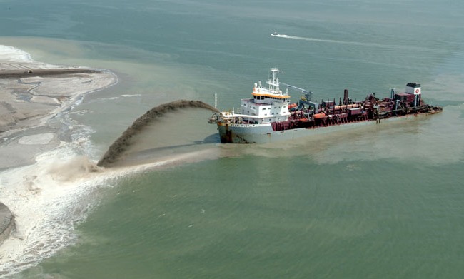
To complete the reclamations, cutter suction dredgers and trailer suction hopper dredgers claimed sand from borrow sites 25-68 miles (40-110km) away in the South China Sea, offshore of Riau Province, Indonesia, and Malaysia. Meanwhile, crane barges and grab dredgers dredged the sand-key trench for shore protection. The dredgers then transported the fill, and either pumped it ashore or used direct placement or “rainbowing,†an economical method that delivers huge quantities of sand by projecting it through the air via a high pressure jet without the need for floating pipelines or other associated equipment. Alternately, hopper barges used the bottom-opening method to deposit fill in specific desired locations.
During the reclamation, a complex system of phases kept current businesses functioning, while the individual land masses were joined. Dredgers first created two large islands from the smaller ones. The next phase represented the largest reclamation contract in history: For $2 billion, Singapore linked these two islands to create a final, large Jurong Island. (6) Finally, the last phase linked the new island to the main island by the 1.4-mile (2.3-km) Jurong Island Highway causeway.
Jurong Island is a dynamic landmass, and JTC constantly explores options to enhance the island's industrial environment. (7) For example, an eighth island (Pulau Buaya) was joined to Jurong Island through reclamation in 2010. In 2013, the construction of a jetty required additional reclaim land. And current work is taking place to add an extension to the island: A fleet of spud grab dredgers and self-propelled trailing suction hopper dredgers expect to complete the work by mid-2018 for a price tag above $800 million.
Tuas Peninsula: Turning Marshland into Money
Adjacent to Jurong Island, Singapore again resorted to capital dredging to turn average swampland into highly profitable industrial real estate.
In the 1970s, the government eyed the Tuas region – originally little more a swamp that became a rural coastal fishing village – as another potential industrial center. Its proximity to then-planned Jurong Island was key to achieving the government's goal of establishing an important commercial zone for international business. At the same time, though, it was far enough from Singapore's main residential and commercial areas to prevent impacting mainland life. (8)
Tuas Dredging and Reclamation
As with Jurong Island, Tuas Peninsula was a multi-stage production requiring a well-crafted plan. The peninsula can be divided into two segments, based on the completion of reclamation:
- Tuas South is the first section reclaimed, closest to the mainland. This initial reclamation project was completed in phases from 1984 to 1999. Capital dredging for land reclamation created 3.9 square miles (10.22 square km) of new land.
- 2. Tuas South Extension is the newer portion at the southern tip, further seaward. This extension project added another 7.3 square miles (19.08 square km) of new land to the reclaimed island from 2000 to 2008.
As with the capital dredging to amalgamate Jurong Island, JTC once again enlisted PentaOcean for the majority of the Tuas land reclamation efforts. Similar to the Jurong Island process, the Tuas expansion required an inclusive fleet of cutter suction dredgers, trailer suction hopper dredgers, and hopper barges for the land reclamation, while crane barges and grab dredgers dredged the sand-key trench for shore protection.
Operators also used the “landfill method†to extend the Tuas Peninsula. This reclamation method turned waterlogged marsh into usable acreage by filling it with sand to create dry land. First, columns of sand were forced into the soft clay of the sea floor to add stability, then a sand wall was built around the desired reclamation site. Cutter suction dredgers and trailer suction hopper dredgers claimed sand from borrow sites in the South China Sea, offshore of Riau Province, Indonesia, and Malaysia , and then deposited it into the walled-off zone. After compressing the sand, workers built a stone wall on the seaward side and planted vegetation to thwart erosion.
Thanks to extensive capital dredging, the expanded Tuas Peninsula now accommodates heavy industry at the Tuas Industrial Estate. The region has truly become an industrial epicenter, with two of Singapore's four incinerators, a desalination plant, a world-scale renewable diesel plant that is the largest plant of its kind, and the world's largest oil storage facility. Tuas also serves as a major port center, housing the Republic of Singapore's Tuas Naval Base and the Tuas Checkpoint Complex that links the country to neighboring Malaysia.
The Maritime and Port Authority of Singapore (MPA) has ongoing reclamation works to continually enhance the Tuas Extension. Current dredging efforts – which employ around-the-clock fleets of dredgers, barges, and tug boats – are expected to be completed in mid-2014. (9)
Controversies and Conclusions
While there's no doubt that land reclamation achieved through capital dredging has enhanced Singapore's economy, and that without the implementation of this advanced technology, much of the island nation would remain unsuitable for expansion, the continuing efforts to increase viable land mass for urbanization and industrialization has not been met with unanimous approval.
Due to the overwhelming success of Jurong, Singapore has striven to maintain its momentum by meeting the unprecedented demand for buildable sites with an uninterrupted supply. As a result, the country has become the world's largest importer of sand , however, Singapore's ongoing land reclamation projects require substantially more fill sand than the tiny island nation is able to provide for itself.
A political controversy has arisen, with the Malay government claiming that any further expansion along the Tuas Peninsula will encroach into Malaysian territorial waters. (10)
Additionally, the massive volume of sand imports have raised suspicions from both Malaysia and other neighboring countries including Indonesia, Vietnam, and Cambodia over the specter of “sand smuggling,†(11) a practice that can lead to devastating consequences not only on ecosystems at both the borrow sites and the reclamation areas, but on neighboring local economies as well.Global Witness, a multi-national watchdog organization founded in 1993 that primarily investigates and reports on the links between environmental profiteering and human rights abuses (particularly in regard to the exploitation of natural resources), maintains that much of the sand harvested for Singapore's expansion projects has been irresponsibly dredged. In a May 2010 report entitled, “Shifting Sands: How Singapore's demand for Cambodian sand threatens ecosystems and undermines good governance†(12) they caution that the lack of sufficient regulatory oversight within the so-called “sand trade†has resulted in everything from human rights violations, graft, political corruption, misappropriation of funds, and the decimation of local fisheries, to endangering the habitats of several endangered marine species including the Dugong, Irrawaddy and spinner dolphins, and certain species of indigenous sea horses.
The government of Singapore strongly refutes claims posited by various organizations that it has broken any laws or environmental guidelines in obtaining sand for its expansion project. They hold that they purchase the sand commercially from private firms operating out of various countries, and it is the job of the exporting countries to police their own citizens and enforce their own laws and regulations. Notwithstanding the controversies that have arisen surrounding the procurement of such massive amounts of sand, it's clear that Singapore's expansion initiatives will continue for the foreseeable future.
Resources and Citations
1. "Singapore's Economic Development": http://geography.about.com/od/economic-geography/a/Singapore-Economic-Development.htm
2. Wikipedia: "Singapore.": http://en.wikipedia.org/wiki/Singapore
3. Singapore has sufficient land to accommodate projected 6.9m population by 2030: http://news.xin.msn.com/en/singapore/singapore-has-sufficient-land-to-accommodate-projected-69m-population-by-2030
4. Oil and Gas Week: "The Island": http://www.theoilandgasweek.com/191212/article.html
5. Wikipedia: "Jurong Island": http://en.wikipedia.org/wiki/Jurong_Island
6. Oil and Gas Week: "The Island": http://www.theoilandgasweek.com/191212/article.html
7. JTC: "Real Estate Solutions / Jurong Island": http://www.jtc.gov.sg/RealEstateSolutions/Jurong-Island/Pages/default.aspx
8. Absolute Astronomy: "Tuas": http://www.absoluteastronomy.com/topics/Tuas
9. SeeNews Shipping: "Singapore Port Continues Reclamation Works at Tuas View Extension": http://shipping.seenews.com/news/singapore-port-continues-reclamation-works-at-tuas-view-extension-378178
10.Coastal Care: "Singapore Extends its Coastlines with Illegally Dredged Sand": http://coastalcare.org/2011/02/singapore-extends-its-coastlines-with-illegally-dredged-sand
11.Coastal Care: "Singapore Sand Imports Threaten Cambodian Ecosystem": http://coastalcare.org/2010/05/singapore-sand-imports-threaten-cambodian-ecosystem
12.Shifting Sands: "How Singapore's demand for Cambodian sand threatens ecosystems and undermines good governance": http://www.globalwitness.org/sites/default/files/pdfs/shifting_sand_final.pdf